
.svg)


SEE SOLUTIONS
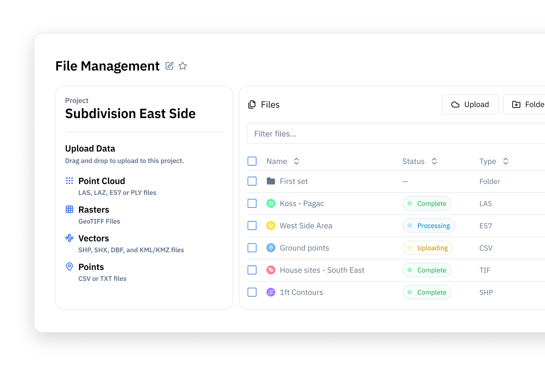
2D/3D File Management
Got point clouds, orthos, contours, or other spatial data? Stitch3D helps you securely host and manage every scan on the cloud with drag-and-drop upload, instant previews, and zero installs or hardware headaches.
Multiplayer Viewer
The industry's first real-time multiplayer web viewer that lets up to 50 users simultaneously markup, annotate, and comment. Welcome to the future of reality capture.
Secure Sharing
Whether you're emailing a client, posting a public link, or generating a QR code for a live demo, it is easy to showcase your work. Control access with permissions and track every shared file from one simple dashboard.
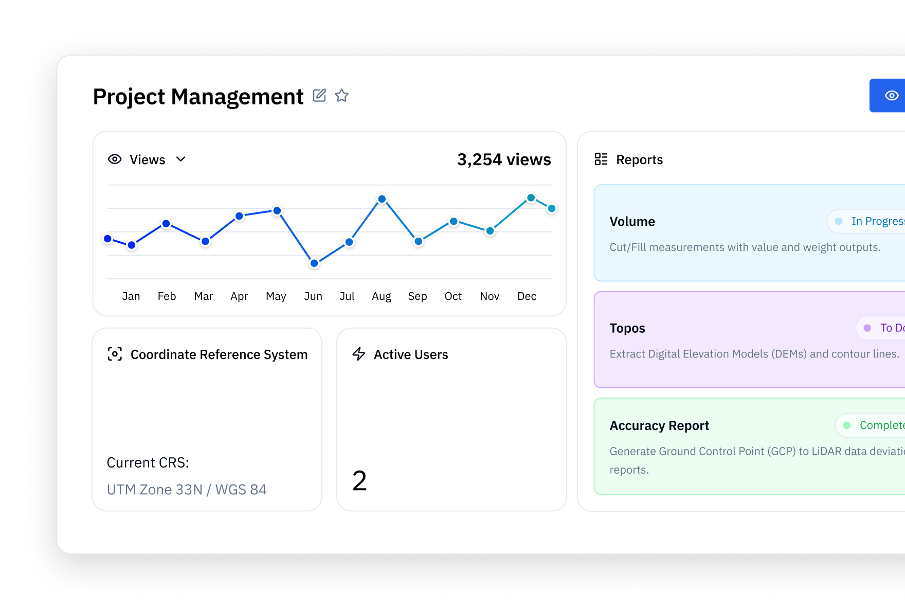
Georeferenced Maps
Stitch3D automatically detects your file coordinate projection and aligns it with accurate map displays. Layer your georeferenced 2D orthos or 3D point clouds on a satellite or street basemap to give every scan full spatial context.
Volume Tools
Stitch3D’s volume tool lets you calculate weight and value in seconds. Measure cut/fill volumes and surface areas with precision.
Create and Export Reports
Generate annotation, volume, or accuracy reports with one click. Easily export to CSV or PDF files for efficient client delivery and complete data transparency.

Matthew Byrd
Reality Capture Network, Founder
One of the biggest challenges we face in the industry is making reality capture data usable and shareable across teams without bottlenecks or siloed workflows. Stitch3D is breaking down those barriers and has made point cloud data more usable for everyone.

Dylan Gorman
Pilotbyte, Founder
Stitch3D has completely streamlined how I deliver complex UAV point cloud data to my clients. It allows me to present info in a way that even non-technical decision makers can easily understand.

Lt Col John LeGloahec
Air Force, 627 CES Commander
Our team worked with Stitch3D to assess the use of drone LiDAR and cloud-enabled software to inspect 1,000 acres of trees. The project was a tremendous success.

Marcus Gilmore
Contour Mapping Pros, Owner
I’m excited to fully integrate Stitch3D into my workflows! It’s the best way to share and collaborate on point clouds while helping me consolidate other software.

Brad Bigham
Brad’s Dronex TX, Owner
This software is and will be a game changer! I’ve been kicking around getting Pix4D cloud for sharing and review purposes alone. Stitch3D is a better choice.

Casey Pryor
Basemap Consulting, Vice President
Absolute game-changer for our operations. Thanks for listening to the community and giving the users the tools they long for in a cloud-based software.
Matthew Byrd
Reality Capture Network, Founder
One of the biggest challenges we face in the industry is making reality capture data usable and shareable across teams without bottlenecks or siloed workflows. Stitch3D is breaking down those barriers and has made point cloud data more usable for everyone.
Dylan Gorman
Pilotbyte, Founder
Stitch3D has completely streamlined how I deliver complex UAV point cloud data to my clients. It allows me to present info in a way that even non-technical decision makers can easily understand.
Lt Col John LeGloahec
Air Force, 627 CES Commander
Our team worked with Stitch3D to assess the use of drone LiDAR and cloud-enabled software to inspect 1,000 acres of trees. The project was a tremendous success.
Marcus Gilmore
Contour Mapping Pros, Owner
I’m excited to fully integrate Stitch3D into my workflows! It’s the best way to share and collaborate on point clouds while helping me consolidate other software.
Brad Bigham
Brad’s Dronex TX, Owner
This software is and will be a game changer! I’ve been kicking around getting Pix4D cloud for sharing and review purposes alone. Stitch3D is a better choice.
Casey Pryor
Basemap Consulting, Vice President
Absolute game-changer for our operations. Thanks for listening to the community and giving the users the tools they long for in a cloud-based software.

Richard Allen
City of Orlando, City Surveyor
Stitch3D has been excellent for integrating and visualizing our survey data. I’ve shared point clouds across multiple teams within the City of Orlando and it was very well received.

Julia Guerra
FlyGuys, Aerial Operations Solutions Architect
Stitch3D is a game changer for large LiDAR data viewing. It’s such a powerful tool.

Earl Bakke
ScenePhoto360, Founder
Stitch3D has been an absolute pleasure to use! The program is incredibly user friendly and intuitive, making it easy to dive right in and start producing results.

Don Won
2cofly, President
Stitch3D really understands our needs as drone service providers. You’re solving a real challenge for me and your platform will help us get our data to more people :)

Michael Olsen
Oregon State University, Professor of Geomatics
Stitch3D removes the major bottleneck in accessing and visualizing massive point clouds, freeing faculty and students to focus on analysis. It’s simple, intuitive, and powerful.

Alvaro Cortes
Visio MX, CTO
This is hands down the most amazing point cloud viewer out there, by no contest. And our clients love it…no nonsense and near zero training required.
Richard Allen
City of Orlando, City Surveyor
Stitch3D has been excellent for integrating and visualizing our survey data. I’ve shared point clouds across multiple teams within the City of Orlando and it was very well received.
Julia Guerra
FlyGuys, Aerial Operations Solutions Architect
Stitch3D is a game changer for large LiDAR data viewing. It’s such a powerful tool.
Earl Bakke
ScenePhoto360, Founder
Stitch3D has been an absolute pleasure to use! The program is incredibly user friendly and intuitive, making it easy to dive right in and start producing results.
Don Won
2cofly, President
Stitch3D really understands our needs as drone service providers. You’re solving a real challenge for me and your platform will help us get our data to more people :)
Michael Olsen
Oregon State University, Professor of Geomatics
Stitch3D removes the major bottleneck in accessing and visualizing massive point clouds, freeing faculty and students to focus on analysis. It’s simple, intuitive, and powerful.
Alvaro Cortes
Visio MX, CTO
This is hands down the most amazing point cloud viewer out there, by no contest. And our clients love it…no nonsense and near zero training required.
Matthew Byrd
Reality Capture Network, Founder
One of the biggest challenges we face in the industry is making reality capture data usable and shareable across teams without bottlenecks or siloed workflows. Stitch3D is breaking down those barriers and has made point cloud data more usable for everyone.
Dylan Gorman
Pilotbyte, Founder
Stitch3D has completely streamlined how I deliver complex UAV point cloud data to my clients. It allows me to present info in a way that even non-technical decision makers can easily understand.
Lt Col John LeGloahec
Air Force, 627 CES Commander
Our team worked with Stitch3D to assess the use of drone LiDAR and cloud-enabled software to inspect 1,000 acres of trees. The project was a tremendous success.
Marcus Gilmore
Contour Mapping Pros, Owner
I’m excited to fully integrate Stitch3D into my workflows! It’s the best way to share and collaborate on point clouds while helping me consolidate other software.
Brad Bigham
Brad’s Dronex TX, Owner
This software is and will be a game changer! I’ve been kicking around getting Pix4D cloud for sharing and review purposes alone. Stitch3D is a better choice.
Casey Pryor
Basemap Consulting, Vice President
Absolute game-changer for our operations. Thanks for listening to the community and giving the users the tools they long for in a cloud-based software.
Stay ahead of outages and overgrowth. Visualize corridors, detect obstructions, and streamline inspections with geo-referenced 3D scans.
Plan ahead or investigate after the fact with confidence. Use point clouds for pre-incident planning, forensic analysis, and fast, accurate accident reconstruction.
Map terrain and infrastructure with clarity. Stitch3D simplifies large LiDAR datasets, letting you overlay maps and create shareable flythroughs.
Catch costly errors before they happen. Compare As-Planned to As-Built environments to monitor progress, flag discrepancies, and reduce delays.
Monitor assets and measure with confidence. From tank volumes to flare stacks, use 3D point clouds to inspect infrastructure, verify compliance, and streamline maintenance without slowing down operations.
Measure material accurately and monitor site changes in real time. Stitch3D lets you calculate stockpile volumes, track excavation progress, and visualize terrain shifts to support planning, reporting, and safety.
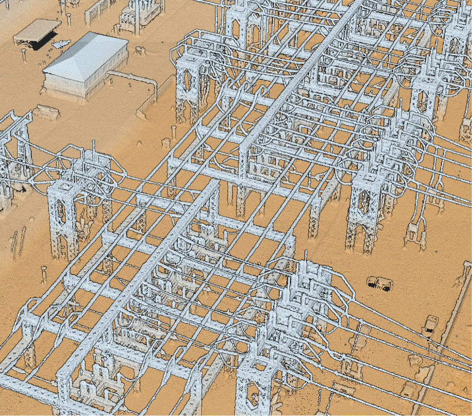
Utilities
Stay ahead of outages and overgrowth. Visualize corridors, detect vegetation obstructions, and streamline inspections with georeferenced 3D scans.
Military / Law Enforcment
Analyze building damages or assess route conditions. Use point clouds for pre-incident planning, forensic analysis, and fast, accurate accident reconstruction.
Surveying
Map terrain and infrastructure with clarity. Stitch3D simplifies large LiDAR datasets, letting you overlay maps and create shareable flythroughs.

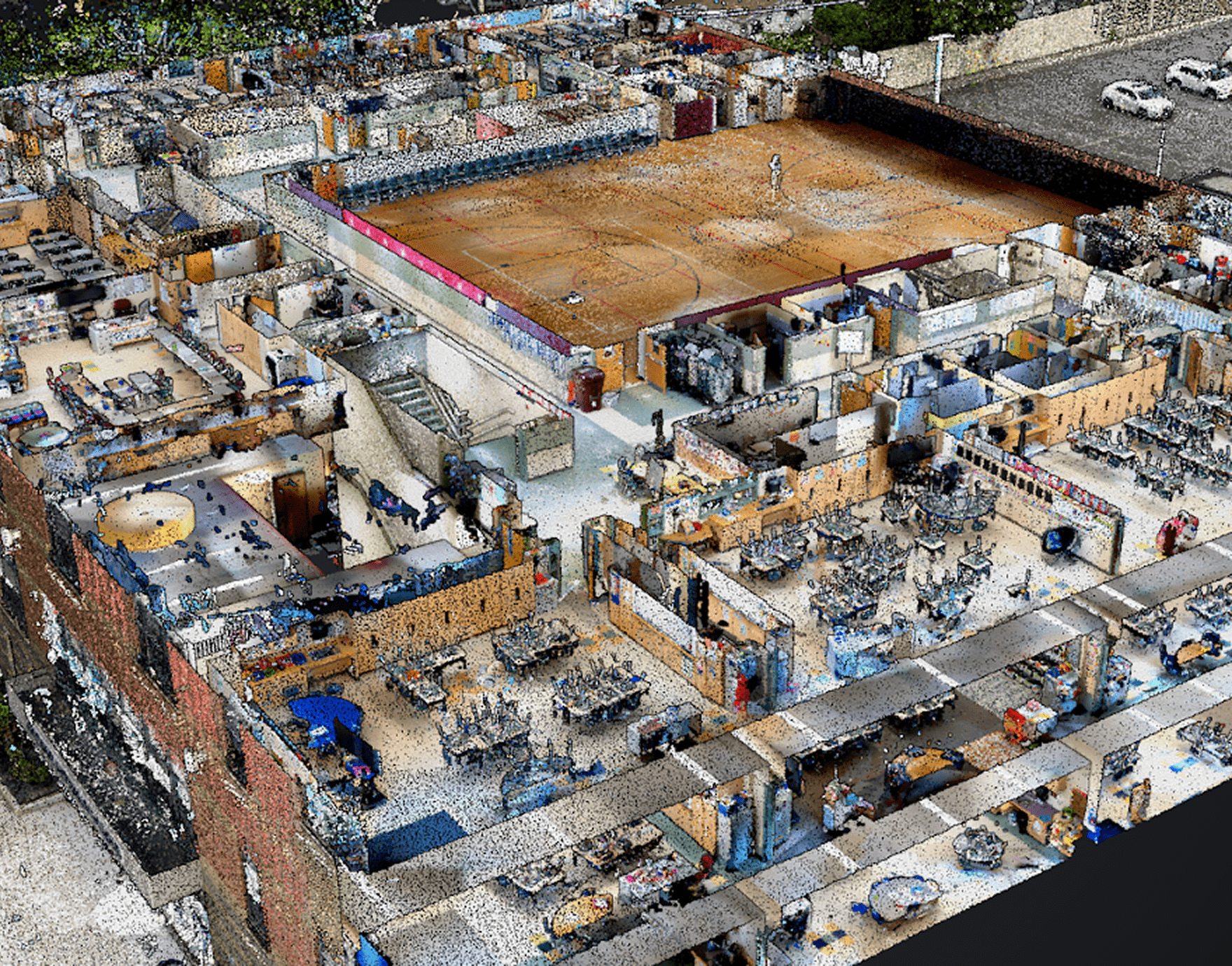
AEC
Catch costly errors before they happen. Compare As-Planned to As-Built environments and open dollhouse views to monitor progress, flag discrepancies, and reduce delays.
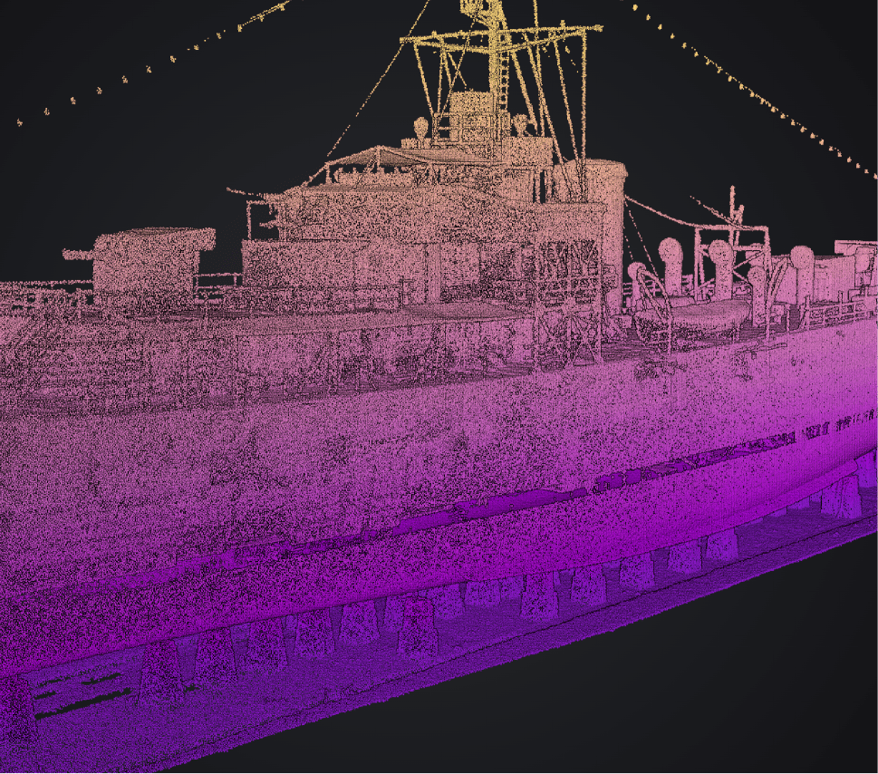
Oil & Gas
Monitor assets and measure with confidence. From tank volumes to rig inspections, use 3D point clouds to audit infrastructure, verify compliance, and streamline maintenance without slowing down operations.

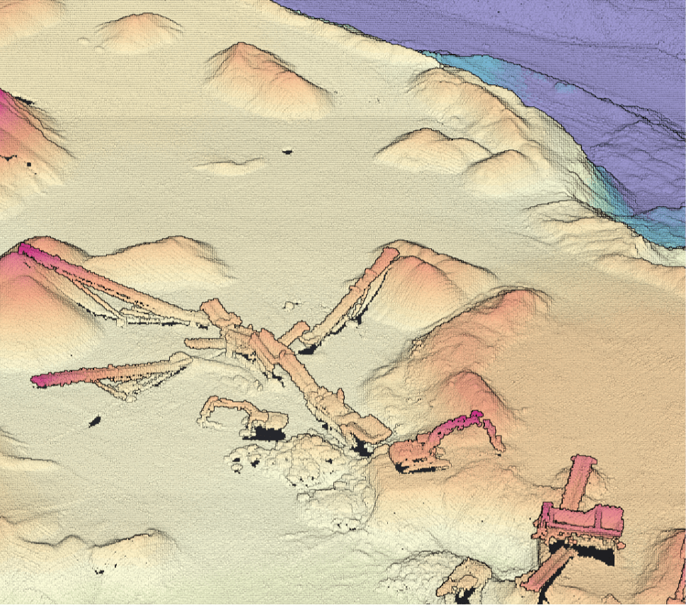
Mining
Accurately measure cut/fill volume and track site changes in real time. Stitch3D lets you calculate stockpile weight and price, track excavation progress, and visualize terrain shifts to support planning, reporting, and safety.
SIGN UP FREE
© 2025 Stitch3D. All rights reserved.